Angus Place West Briefing Note is a detailed briefing by the Gardens of Stone Alliance
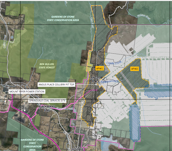
Map showing proposed Angus Place Mine in the Gardens of Stone Region
Map of the Gardens of Stone Regional Locality
Centennial Coal plans to reopen the Angus Place Colliery, that has been mothballed since 2015. In August 2021 Centennial submitted a Scoping Report to the Planning Department for its Angus Place West proposal. The company plans to extract up to 8.5 millions tonnes of coal at a rate of up to 2 million tonnes a year. The proposal covers 1,000 hectares and would mine under the Gardens of Stone State Conservation Area.
On July 11th, 2022 Centennial Coal submitted a referral 2022/09270 under the Federal Environmental Protection and Biodiversity Conservation Act claiming that Long Swamp, and swamps on Kangaroo and Lambs Creeks are not "matters of national environmental significance". The regulators did not agree. Assessment of potential impacts will be controlled under Federal Environmental law. The Federal Environment Department found that the proposed mining could impact World and National Heritage places, threatened species and communities, listed mitgratory species and water resources.
These three swamps, mapped as nationally endangered Temperate Highland Peat Swamps on Sandstone, are still claimed by Centennial Coal not to be listed swamps. The mapping research was undertaken as part of an enforceable undertaking paid by Centennial Coal. Further information on the enforceable undertaking and the terms of the THPSS Research Program.